
Hiking in the South of France
A Hike Offering a Ultimate View of the Riviera
Like a good story, the walk from Beaulieu to Eze-sur-Mer reveals its plot in many twists and turns
If I read an article about hiking and the author recommends a specific trail by praising its view, I know immediately: this is a walk I will want to avoid. This is because views on hikes are either fleeting, something you glimpse for a moment or two before, inevitably, you move on, or they are something that overstays its welcome.
I mean, what’s so great about staring at the same object from different angles, for hours on end? No matter how spectacular the view: after a while, you are beginning to lose interest. Which is why, when I read about the magnificent and spectacular views you get during a walk, I quickly turn the other page.
That has always been my rule – until last week, that is, when I found out that, as in every rule, this one has its exceptions, too.
So let me recommend the trail from Beaulieu-sur-Mer to Eze-sur-Mer on the French Riviera by pointing out that it’s a hike offering a ultimate view of the Riviera, is magnificent and spectacular.
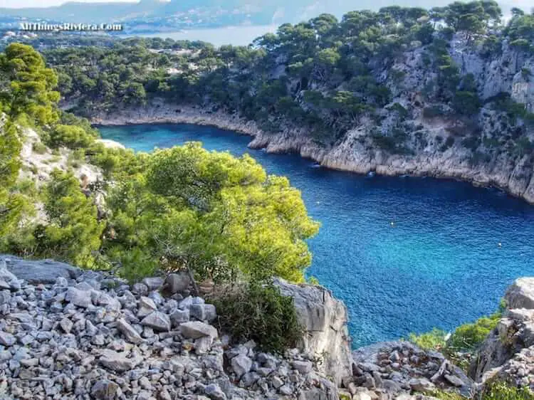
What makes it so “exceptional”? The view you get across the Mediterranean from the southern slopes of Saint Michel mountain is, in reality, not really a single view at all.
Climbing up this trail is not like looking at the same object for several hours from different angles but more like spending some time with an interesting character in a movie or a play.
With every change of scenery, with every twist and turn of the plot (or the path), you find out something new and reveal something else.
The first thing you see after you have left the suburbs of Beaulieu-sur-mer behind you and are entering the open countryside, is the town’s elegant yacht harbour…

… before the view opens up to include the Cap Ferrat peninsula, with the town of Saint Jean Cap Ferrat nestled in the small bay near the isthmus in the middle.

One level further up, the next bay slowly comes into view; this is the Rade de Villefranche, one of the French Riviera’s most celebrated spots …

… and the higher you climb, the more you can see of Villefranche-sur-mer itself, the picturesque village which was initially still hidden behind the trees on your right hand side.

But the best is yet to come …

… because near the top of the Saint Michel mountain, you can look past Mont Boron on the eastern outskirts of Nice into the Baie des Anges, over the city of Nice all the way to its airport and beyond – the long stretch of land on the far side of the picture leads you already straight to Cap Antibes.
This is pretty much the entire Riviera coast lying at your feet there, condensed into a single view. Things do not get much better than this.

A little better, still – there is, after all, always room for another small improvement.
On the top of Saint Michel mountain, while having a well-deserved picnic on the plateau, you can, observe the planes in the last stages of their approach towards Nice airport, moving across the waves of the Mediterranean Sea like flying fish, and, higher up in the sky, the helicopters that ferry some oligarch or the other from Nice airport to Monaco.
Now, if that is not the ultimate view of the French Riviera!
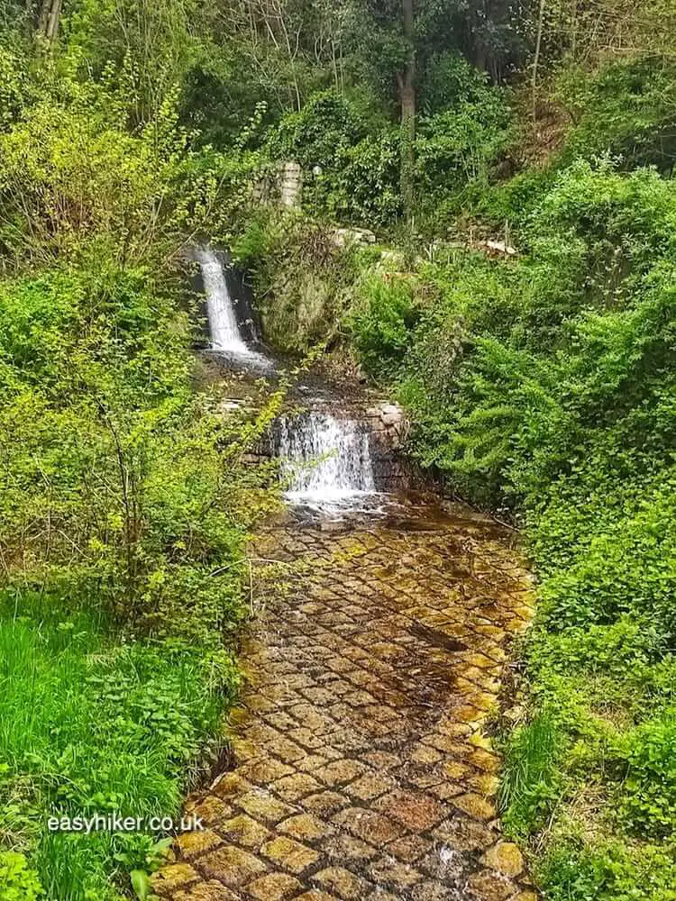
The second half of the trail from the plateau Saint Michel to the seaside town of Eze-sur-Mer is a little less spectacular – apart from the waterfall you will need to cross and a long stretch of quicksand.
Actually, the “quicksand” was not really that quick and most likely the combination of a building work overspill (this was already in the outskirts of Eze) and too much rain, while the waterfall was real enough, but could be crossed a little to the left where the river – okay: the creek that would eventually tumble down into the valley underneath was only a few feet wide. But still ..

The Beaulieu-to-Eze walk (total length: about 7 km / 3 hours) starts at the train station of Beaulieu-sur-mer (a regular stop on the line from Cannes to Ventimiglia).
Turn right out of the station and – after 200 metres – left into Rue Eugene Gauthier before joining the Montee des Mandarines and climbing all the way up to the RD 67 road, the legendary “Moyenne Corniche”.
Turn right along the guard rails in the direction of the tunnel, and cross where the rails open up to leave a gap: the path continues on the other side, right up to the Plateau Saint Michel.
On the way down from the plateau, use the Sentier Libac and the Sentier La Pinède. Always follow the yellow balisage marker: if you haven’t seen one for 200 metres or more, you may have taken a wrong turn.
The trickiest spot of the trail is right at the beginning of the descent from the plateau where the arrow on a signpost can be interpreted in more than one way. You have to cross the asphalted road here and continue straight into the gap between two gardens.
There is a yellow marker, too, but it’s well hidden. Can you spot it?


Thanks for the tips, Brent! And really not surprised that you loved the hike! That’s one of our favourites now. We have also done the hike in Eze (see: https://easyhiker.co.uk/eze-hiker-in-french-riviera/)
Did the hike today. Was excellent.
A couple of suggestions.
1. Load google maps with your WiFi before you go and all of the trails are marked making it much easier to follow.
2. When heading up rue eugine Gautier, keep heading straight into what looks like someone’s driveway and then up some stairs. The sign for Montes Mandarins does not appear for a while.
3. Another nice hike we did today was from Eze Sur Mer where this hike ended up to Wze village in the mountains. It is well marked and better footing and about one hour up and 45 minutes down, than a half hour walk along the coast to Beaulieu Sur Mer.
Please consult here:http://www.randoxygene.org/pge/rando_pe/affiche_rando.php?rubrique=1&zone=3&rando=13¤t=pc-18&ct=pc You can also ask for the hardcopy Guide Randoxygene at any tourism office.
Bus line no. 100 from Nice (Place Garibaldi) or Monaco (Bus stop Sainte Devote/train station) and get off at either bus stop Beaulieu Port or Eglise. Every 10 to 20 minutes. You can buy your ticket on the bus.
Alternatively, you can also take the train to Beaulieu-sur-mer and take it from there. Easier, but slightly more expensive (and less fun because you see more from the bus).
You’ll enjoy this hike. Thanks for dropping by, Hideko
Is any chance you can include in your article maps of the trail area and transportation information(bus #, train…etc)from Nice.
There are indeed quite a number of hikes and walks one can do in the South of France and we intend to do most of them, Bob. Thanks for dropping by.
Great to see that you’re spending more time in this area. Lots of great hikes to look forward to. I’ve been to Monaco dozens of times for work and always enjoyed best the near-solitary walks up the coast.
Oh wow! The pictures are beautiful. What a hike! Thanks for sharing.
Please don’t laugh, but I’ve never thought of the French Riviera and hiking in the same sentence before until you prompted the thoughts. I would totally love to do this walk!
Thanks for the warning, I will be well prepared
(Greetings from Pretoria, South Africa).
Be aware that August is the height of summer in the Cote d’Azur. It could be very hot so be prepared. Thanks for dropping by.
Thanks, very useful . Planning my hikes south of France for August 2014.